Pàgina 12 de 20
Re: Plànols de propostes ferroviàries per Barcelona
Publicat: Diumenge 19/04/2015 12:56
Autor: davroca5
carto.metro ha escrit:Thanks for the replies !
Don Ramón ha escrit:Construction on Metro line L9 has been halted indefinitely, so the works at Sarrià are at a standstill.
There is no date for opening the central section ? Is the tunnel finished now ? What is the remaining work ? rail track, signalling and station equipment ?
Yes, the central section between Zona Universitaria and La Sagrera are stopped. The section between Manuel Girona and Lesseps has not been perforated. The section between Lesseps and La Sagrera is completely perforated but the slab between the two parts of the tunnel is not completed. The execution percentage of the stations are 20-50%, I think.
Sorry for my poor English

Map orientation and train network
Publicat: Diumenge 19/04/2015 13:15
Autor: Javi M
Hello CartoMetro! Congratulations for your work! I really like your map, so much that I'll print it in a A0 poster after you release the upgrade!
I'd say that in Barcelona, all the maps (not only metro maps) are oriented parallel to the shore, not N-S. By this reason you map looks a little bit strange, and if it's not a hard work, I'd recomend you to rotate it to make the sea line horitzontal.
I also think include train network wold be marvelous. In my opinion, the city network is not as simple as two tunnels, but it's much smaller and simplest than metro network.
Re: Plànols de propostes ferroviàries per Barcelona
Publicat: Diumenge 19/04/2015 14:47
Autor: bigcoaster
carto.metro ha escrit:Thanks for the replies !
Don Ramón ha escrit:Construction on Metro line L9 has been halted indefinitely, so the works at Sarrià are at a standstill.
There is no date for opening the central section ? Is the tunnel finished now ? What is the remaining work ? rail track, signalling and station equipment ?
The central section has been stopped with no date to restart the construction.
bigcoaster ha escrit:In this fanthastic map you could include the commuter lines too, because it's not very difficult (there're only 2 tunnels with 2 tracks and Barcelona Sants) and would be very useful
You mean the tunnels of the rodalies networks ? That is "little" bit more than just two tunnel I think

The two TBMs are at Manuel Girona and Lesseps. So, generally, the central part has not been bored yet. The Camp Nou station will not open because it is the bored soil extraction point, it is where the converyor belt from the TBM at Manuel Girona arrives. Due to this conveyor belt, in the section that will open, trains will run in only one track between Collblanc and Zona Universitària.
The commuter network is not easy but far from complicated. The two tunnels are formed by only two tracks, and all the lines that go out from Barcelona ara double-tracked. The complicated part would be Barcelona-Sants, because it has a lot of tracks, 6 for UIC and the rest for iberic wide.
Thanks for your interest!
Re: Plànols de propostes ferroviàries per Barcelona
Publicat: Diumenge 19/04/2015 14:53
Autor: Carlos González
carto.metro ha escrit:Hello,
I'm updating the Bacelona track map (after 4 years, there some work to do...).
I would like to know if the works at
Sarriàand
Gràcia are finished, and if the inset I draw on the map show the new situation correctly ?
Thanks a lot,
Franklin
I had seen this map before than make me a member of this forum, hehehe

, and I think than the works of the stations Sarrià and Gràcia, it not have been finished yet. I'm not sure


. And the map is very nice

And sorry if I wrote bad some word

Re: Plànols de propostes ferroviàries per Barcelona
Publicat: Diumenge 19/04/2015 17:46
Autor: carto.metro
Ok, thanks for the details, there is still a lot of work to do on L9-L10 to finish it

Sorry Javi, It' difficult to turn the map and keep the text horizontal (and btw, it won't work correctly on the
online map, because it's georeferenced).
I'll think about adding the commuter network for a later update. I'll correct the existing map first !
Re: Plànols de propostes ferroviàries per Barcelona
Publicat: Diumenge 19/04/2015 20:43
Autor: jaezcurra
Hi carto.metro,
A tramway station has changed its name: T4 and T6 Central Tèrmica station has been changed to Port Fòrum (
http://www.btv.cat/btvnoticies/2015/04/ ... port-foru/).
Further info
Publicat: Diumenge 19/04/2015 21:29
Autor: Guigui
Hi CartoMetro!
For further information on the works you asked about, refer to the following threads:
http://www.transport.cat/viewtopic.php?f=2&t=2322
http://www.transport.cat/viewtopic.php?f=2&t=10620
Although Google Translate or similar tools are quite gloomy, they will do fine to grasp the general meaning of what is said there.
Re: Plànols de propostes ferroviàries per Barcelona
Publicat: Dilluns 20/04/2015 16:03
Autor: metring
Estic flipant o hi han missatges en anglès?
Re: Plànols de propostes ferroviàries per Barcelona
Publicat: Dilluns 20/04/2015 16:59
Autor: Ganz
Yes, metring !!
FMTC
Publicat: Dilluns 20/04/2015 17:18
Autor: Guigui
metring ha escrit:Estic flipant o hi han missatges en anglès?
Dedueixo que l'usuari CartoMetro no domina el català ni el castellà, i per a la seva feina, ha demanat alguns detalls.
Algun dia, serem el Fòrum Mundial del Transport Català. O ja ho som?
Re: Plànols de propostes ferroviàries per Barcelona
Publicat: Dimarts 21/04/2015 12:28
Autor: pcongre
metring ha escrit:Estic flipant o hi han missatges en anglès?
A la foguera tots plegats!
Re: Plànols de propostes ferroviàries per Barcelona
Publicat: Dissabte 25/04/2015 22:20
Autor: carto.metro
metring ha escrit:Estic flipant o hi han missatges en anglès?
Si porque mi espagñol not esta correcta (y tambien catalan...).
Una nueva versión de la mapa con las correcciones está disponible:
http://carto.metro.free.fr/metro-tram-barcelona/
Altra versió.
Publicat: Divendres 22/05/2015 23:43
Autor: Renfe445
Com que amb la inauguració de la línia 9 de l'Aeroport del Prat fins a Zona Universitària pot col·lapsar el mapa actual, doncs heus aquí un disseny més simplificat del mapa. Suposo que a alguns els serà més difícil la seva orientació, però el mapa creix!
Sé que és una altra "flipadeta" de les meves. Està incomplet, però m'agradaria ensenyar-vos aquests esborranys que estic fent:
 La línia 11 la he intentat indicar com l'antiga línia Epping - Ongar de la Central Line, per exemple.
Re: INAT: Metro Maps
Publicat: Dissabte 23/05/2015 0:27
Autor: davroca5
M'agrada, però seria interessant afegir Rodalies i TRAM's, a part d'indicar L9 i L10 amb colors diferents

Re: INAT: Metro Maps
Publicat: Dissabte 23/05/2015 10:17
Autor: bigcoaster
M'agrada, i molt!
No sé si ho has fet volent o t'ha sortit així però m'agrada molt que els enllaços més llargs a la vida real siguin més llargs al mapa del metro, i així de manera instintiva aniràs per l'enllaça més curt i còmode. També m'agrada molt com has posat la L11, tot i que la gent pot creure que si està en un tren de la L4, seguirà cap a Can Cuiàs. També m'agrada molt com has resolt la part de Cornellà i la Torrassa, que al mapa actual està tot enganxat i es fa lleig i confús. Està molt bé com has fet acabar Can Zam i com has fet la L1 recta per la Meridiana, que així és més fàcil de seguir amb la vista.
Coses que canviaria, diferenciar la L9 i L10, també en la part que van juntes (mostrar que hi ha el doble de freqüència i que pots agafar qualsevol de les dos en qualsevol lloc). La L3 i la L5, als voltants de Vall d'Hebron, els faria com estan ara al mapa, que s'ajusta més a la realitat i dóna la sensació de cobrir molt bé els buits.
Em moro de ganes de veure com queda el traçat sud de la L9!!
Re: INAT: Metro Maps
Publicat: Dissabte 23/05/2015 11:58
Autor: Renfe445
Home, la línia 9 i la línia 10 es poden considerar com a una línia única que té dos ramals als extrems. Ho he fet com, per exemple, la S2 i la S25 de la S-Bahn Berlin.
Tenia pensat anomenar les línies amb una U al davant:
U1
U2
U3
U4/U45 (La U45 és la línia 11)
U5
U6
U7
U8
U9/U95 (Nord) - U91/U96 (Sud)
Això serà una mica absurd, però a mi m'agrada, hehehe

Re: INAT: Metro Maps
Publicat: Dilluns 25/05/2015 21:18
Autor: Renfe445
bigcoaster ha escrit:La L3 i la L5, als voltants de Vall d'Hebron, els faria com estan ara al mapa, que s'ajusta més a la realitat i dóna la sensació de cobrir molt bé els buits.
Ho he fet així per simplificar-ho més i deixar-ho preparat per ficar el traçat de les línies 9 i 10 centrals.
Re: INAT: Metro Maps
Publicat: Dilluns 25/05/2015 22:42
Autor: bigcoaster
Renfe445 ha escrit:bigcoaster ha escrit:La L3 i la L5, als voltants de Vall d'Hebron, els faria com estan ara al mapa, que s'ajusta més a la realitat i dóna la sensació de cobrir molt bé els buits.
Ho he fet així per simplificar-ho més i deixar-ho preparat per ficar el traçat de les línies 9 i 10 centrals.
Impacient per veure la L9/L10! A veure si podries posar-les "en construcció" al mapa, per veure com quedarien. Ja et dic el apa t'està quedant molt bé.
Re: INAT: Metro Maps
Publicat: Dilluns 25/05/2015 23:52
Autor: Renfe445
Gràcies, bigcoaster...
Encara no he fet la línia 9 per la part del Prat i L'Hospitalet de Llobregat, però...

Cliqueu la imatge per veure-la sencera.
Re: INAT: Metro Maps
Publicat: Dimarts 26/05/2015 0:23
Autor: Granolleri
Renfe445 ha escrit:U1
U2
U3
U4/U45 (La U45 és la línia 11)
U5
U6
U7
U8
U9/U95 (Nord) - U91/U96 (Sud)
Lo de "U8" sobra, molt millor el que tenia abans: S3. Tot i que si fos per mi, a la Llobregat-Anoia només hi hauria R5 i R51 (per el ramal d'Igualada), indicant per als trens que no paren a tot arreu a sota la menció "Semidirecte ". Un estil a això:
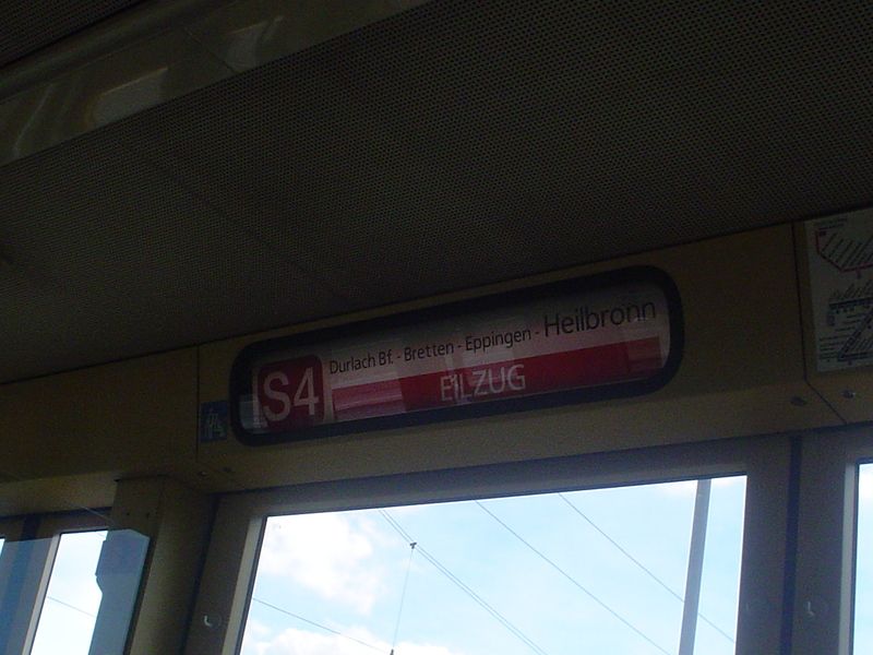
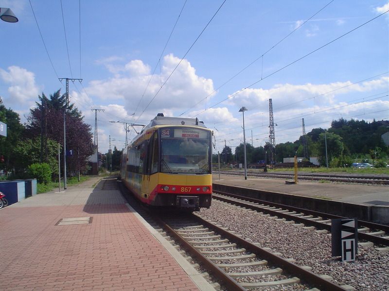
Les fotos són del Stadtbahn de Karlsruhe, fetes al meu primer viatge a Alemanya l'estiu del 2008.

